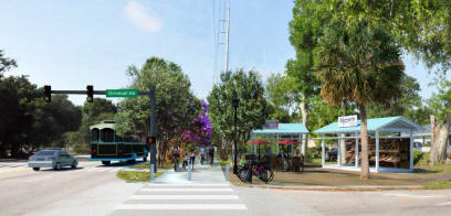
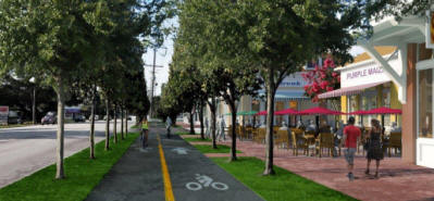
RETHINK FOLLY ROAD
A Complete Streets Study has been completed by the BCDCOG in association with the City of Charleston, the Town of James Island, the City of Folly Beach, Charleston County, the Charleston Area Regional Transit Authority (CARTA), and the South Carolina Department of Transportation (SCDOT). The purpose of this study is to identify the opportunities and explore the potential to transform the Folly Road corridor into a more sustainable, multimodal corridor, which could serve as a precedent for the Charleston Region.
Purchase copies of the report .
Download Report
Download Appendix
How was the Vision Created?
A week-long public design charrette was held in May 2015. Communitymeetings provided opportunities for group brainstorming and input; an open study allowed community members to have one-on-one conversations with members of the planning team as draft ideas were being explored. Feedback was gathered through written surveys and keypad polling; in addition, a MindMixer site (follyroad.mindmixer.com) was launched to allow online participation. Following the charrette, concepts were refined with input from the multi-jurisdictional project Steering Committee. A Community Open House was held in August 2015 to gather additional feedback on the draft ideas and summary report.
What are the Main Ideas?
Through the charrette, five “guideposts” were established (Safe | Connected | Green | Valuable | Synced) which express an ideal future for Folly Road. Each improvement recommended by this study promotes one or more guidepost. View the Executive Summary and Project Summary Report and Appendix below for more information on the ideas and recommendations.
Documents & Downloads
RFR Steering Committee Meeting Minutes
4/16/19
3/27/19
1/23/19
10/24/18
9/26/18
6/27/18
3/18/18
2/14/18
1/17/18
11/29/17
10/26/17
9/14/17
4/27/17
Resources:
Folly Segment Crosswalk Safety Presentation
Rethink Folly Road Executive Summary and FAQ
Rethink Folly Road Appendix
Rethink Folly Road Report – October 2015
RFR Next Steps Presentation – January 2018
RFR Next Steps Phase I – October 2018
Charleston County Stormwater Presentation
4/16/2019 Rethink Folly Segment 1 Update